Free Camping Near Las Cruces NM: Organ Mountains, Desert Waterfalls, and Hot Springs
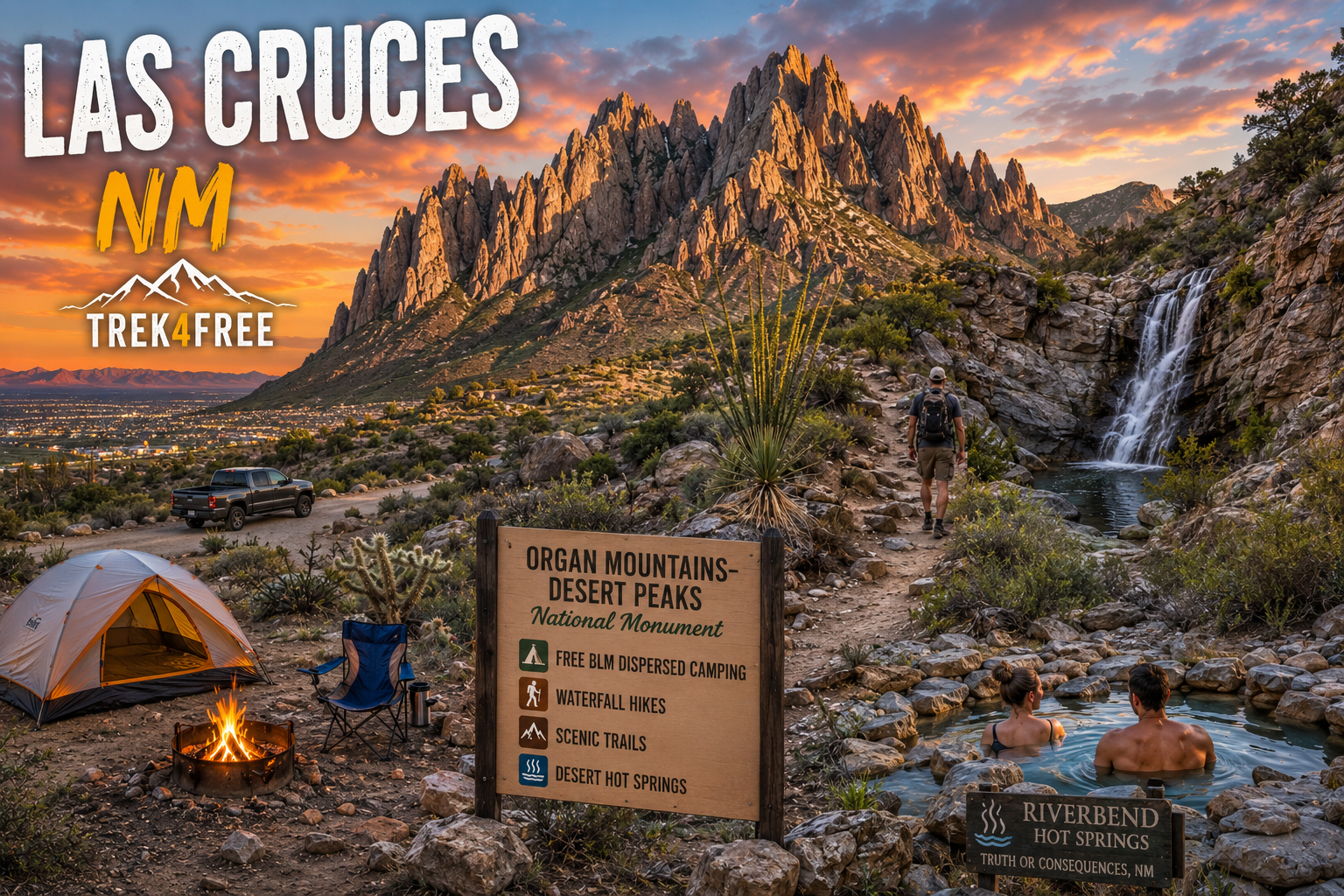
Free Camping Near Las Cruces NM: Organ Mountains, Desert Waterfalls, and Hot Springs
Las Cruces doesn’t look like a free camping destination from the interstate. Strip malls, chain hotels, the usual. But head east nine miles and you’re at the foot of the Organ Mountains — dramatic limestone spires rising 9,000 feet out of the Chihuahuan Desert — with free BLM dispersed camping, four trail systems, and a waterfall in a place you wouldn’t expect to find one.
The whole setup is in Organ Mountains-Desert Peaks National Monument. BLM land. Free camping. No permit required.
Free Dispersed Camping — 9 Miles from Downtown
The closest free camping to Las Cruces is along Dripping Springs Road on the approach to the Organ Mountains. Pull-offs with fire rings, mountain views west over the city lights, and surprisingly solid cell signal for how remote it feels. No water, no trash service — pack in, pack out — but you’re 15 minutes from a grocery store if you forgot anything.
Sierra Vista Dispersed Area on Trek4Free →
Same road leads directly to the Dripping Springs trailheads. You can camp for free, wake up, and walk right into the mountains.
A second dispersed option is along Baylor Canyon Road — flat gravel pull-offs, big-rig friendly, views toward the east face of the Organs. Quieter than Sierra Vista on weekends and easier on low-clearance vehicles.
Northwest of town near the Robledo Mountains, Prehistoric Trackways National Monument offers free 14-day dispersed camping on BLM land with surprisingly good views of Las Cruces at night. No facilities. Free. Worth knowing about if Sierra Vista is full on a weekend.
The Organ Mountains Trailheads
For the developed trailhead experience, Dripping Springs Natural Area is the hub — $5/vehicle day use fee gets you access to four trails, a visitor center with restrooms and water, and one of the more dramatic canyon approaches in southern New Mexico.
Dripping Springs Natural Area on Trek4Free →
Fillmore Canyon Trail — 2.2 miles to a real waterfall. In the desert. That sounds like a mistake but it isn’t — Fillmore Canyon funnels enough runoff from the upper Organs to produce a legitimate falls after rain. The short hike is worth it on its own. The waterfall is a bonus you didn’t see coming when you drove through Las Cruces.
La Cueva Trail connects to a prehistoric rock shelter at the base of the canyon walls — used for thousands of years before anyone called this place New Mexico. The ruins of a historic resort from the 1870s are also accessible from this trailhead system — two kinds of history in one canyon.
Pine Tree Trail is the classic Organs loop — 4 miles, ponderosa pines at elevation, big views across the Tularosa Basin toward White Sands. Starts from the east side of the mountains at Aguirre Spring.
For the best sunrise or sunset hike, Baylor Pass Trail traverses the Organs from east to west — 4.1 miles one way, connecting the two sides of the mountain. The views in both directions at the pass are worth the climb.
Aguirre Spring — The Other Campground
On the east side of the Organ Mountains, Aguirre Spring Recreation Area is a developed BLM campground with 55 sites tucked at the base of the spires, looking east toward White Sands and the Tularosa Basin. $5/night. Alligator juniper, canyon views, and the Pine Tree Trail leaving directly from camp.
Aguirre Spring Campground on Trek4Free →
RV limit is 23 feet due to the access road. No reservations — first come, first served. Worth getting there by Friday afternoon on fall weekends.
Ancient Tracks in the Robledo Mountains
Worth a mention for anyone who goes looking for the unusual: Prehistoric Trackways National Monument in the Robledo Mountains northwest of Las Cruces preserves animal trackways from the Permian period — roughly 280 million years old. These predate the dinosaurs by 50 million years. The tracks include early reptiles, amphibians, and insects preserved in ancient mudflats. Discovered in 1987 by a local amateur paleontologist who spent years documenting what turned out to be thousands of individual tracks. Free BLM land, no entry fee. It shows on the Trek4Free Ancient Sites filter → on the map.
Hot Springs — Worth the Drive
No free hot springs right at Las Cruces, but the closest legitimate option is worth knowing about.
Riverbend Hot Springs in Truth or Consequences is 75 miles north on I-25 — about an hour. Pools ranging from 95°F to 107°F sit directly on the bank of the Rio Grande. This is not a hidden gem; it’s a resort. But the setting is genuine — geothermal water, the Rio Grande flowing past, mountains in every direction. Day use soaking available. If you’re camping near Las Cruces for a few nights, this is the hot spring reward at the end of it.
Hot springs appear on the Trek4Free Explore map → under the Hot Springs filter for the full New Mexico picture.
The Quick Reference
| Spot | Drive | Type | Fee |
|---|---|---|---|
| Sierra Vista Dispersed | 9 miles | Free camping | Free |
| Baylor Canyon Dispersed | 12 miles | Free camping | Free |
| Dripping Springs / Fillmore Canyon | 10 miles | Day hike + waterfall | $5/vehicle |
| Prehistoric Trackways NM | 15 min NW | Ancient tracks | Free |
| Aguirre Spring Campground | 25 miles | Developed camping | $5/night |
| Pine Tree / Baylor Pass Trails | 25 miles | Summit hike | $5/vehicle |
| Riverbend Hot Springs (T or C) | 75 miles | Hot springs resort | Paid |
All free and dispersed camping in New Mexico is on Trek4Free: Browse NM free camping →
More New Mexico: free camping near Taos →. For the best desert Southwest trip planning, start with the Explore map → — filter by Free Camping, Hot Springs, or Ancient Sites.