Free Camping Near Knoxville TN (Cherokee National Forest + Smokies Waterfalls)
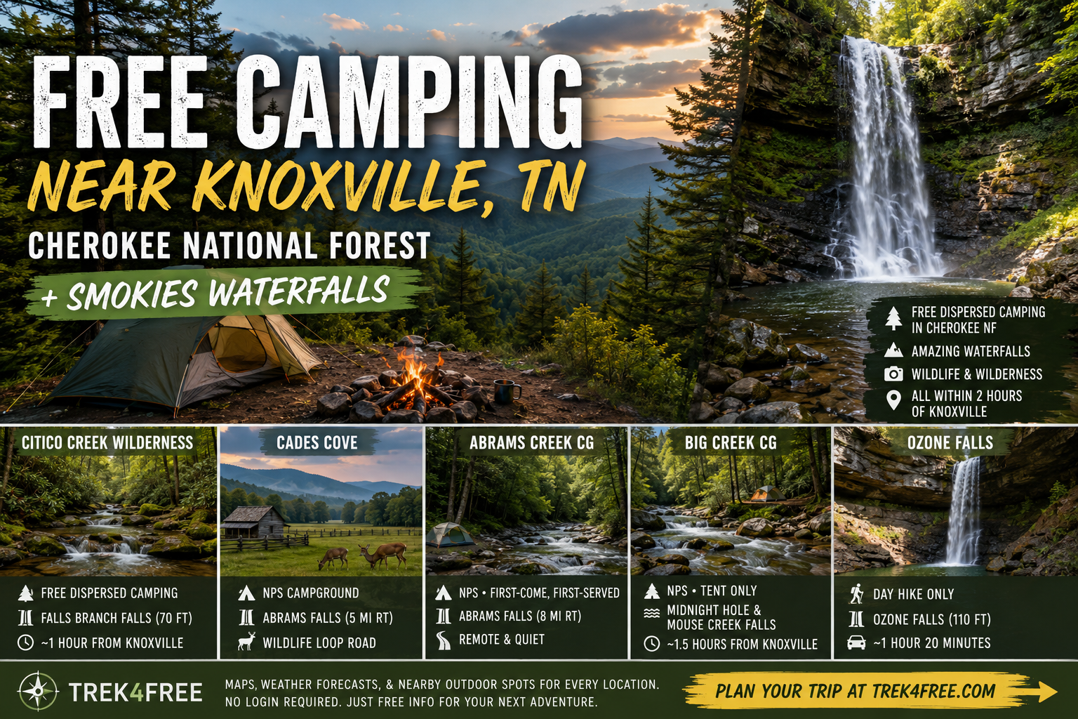
Free Camping Near Knoxville TN (Cherokee National Forest + Smokies Waterfalls)
Great Smoky Mountains National Park is the most visited national park in the United States, and it has no entrance fee. That’s always been true and a lot of people still don’t know it. You don’t pay to drive through. You don’t pay a gate fee. The park exists free of charge for everyone who wants to use it.
What even fewer people know is what wraps around it: Cherokee National Forest. Nearly 650,000 acres of national forest land on the Tennessee side, split into northern and southern sections around the park boundary. Free dispersed camping is permitted throughout most of it. The same system as every national forest — 14-day limit, pack out what you pack in, don’t camp within 200 feet of water. No booking fee. No reservation required.
Knoxville sits at the western doorstep of all of this. You’re one hour from the park entrance, one hour from wilderness camping in Cherokee NF, and about an hour and twenty minutes from one of the most dramatic waterfalls in the state that almost nobody goes to.
Here’s where to go.
Citico Creek Wilderness — The Real Dispersed Option
Free camping, Cherokee National Forest, Monroe County TN
If you want the genuine dispersed experience — deep in national forest, no neighbors, creeks, silence, and access to wilderness trails — Citico Creek is your answer near Knoxville.
The Citico Creek Wilderness is over 20,000 acres of congressionally designated wilderness in the southern section of Cherokee NF, south of the Tellico Plains area. Dispersed camping along forest roads into the area is free, first-come, first-served, and genuinely remote. There’s no cell service. There’s excellent trout fishing. And there is a 70-foot waterfall at the end of a 2.6-mile round trip hike.
Citico Creek Area on Trek4Free →
Falls Branch Falls Hike → — Falls Branch Trail #87, 1.3 miles each way into the Citico Creek Wilderness. The trail follows an old roadbed most of the way before turning steep and rocky near the falls. Minimal signing — it’s designated wilderness, that’s intentional. The falls drop 70 feet. Worth every step.
This is the area Knoxville locals use when they want to disappear for a weekend and not see another soul. That’s the whole pitch.
Cades Cove — Abrams Falls, Wildlife, and the Historic Loop
Fee campground, Great Smoky Mountains National Park, Blount County TN
Cades Cove is not free. I want to be upfront about that — this is an NPS campground with a fee per night. But it earns its mention here for two reasons: the wildlife loop and Abrams Falls.
The Cades Cove Loop Road is 11 miles of paved one-way road through an open valley where white-tailed deer, black bear, wild turkey, and occasionally coyote are visible from your car any morning before 9am. It is one of the best wildlife viewing spots in the eastern United States. The loop is open at sunrise.
Abrams Falls is a 5-mile round trip hike from the campground — a 20-foot waterfall that punches way above its height because of the volume of water pouring through it. The pool at the base is deep and wide and genuinely beautiful. The trail is well-maintained and appropriate for most hikers.
Cades Cove Campground on Trek4Free →
The Smokies have no entrance fee, so once you’ve paid the campground fee, you’re done paying for the entire trip. No additional gate charge, no day-use fee.
If Cades Cove is full (and it fills), there’s a smaller, more remote alternative: Abrams Creek Campground — 16 sites in the far western corner of the park, accessed by gravel road, no reservations. First come, first served. It’s how the Smokies used to feel before the booking systems and the crowds. The Little Bottoms Trail to Abrams Falls leaves from here — 8 miles round trip along the creek instead of 5 miles from Cades Cove. Longer, quieter, better.
Big Creek — Tent Only, Creekside, Midnight Hole
Fee campground, Great Smoky Mountains National Park, NC/TN border
Big Creek Campground is on the far northeastern edge of the Smokies, on the NC side of the state line but oriented toward Knoxville from I-40. Short walk from the parking area to the sites, roaring creek right beside the campground, no hookups, tents only. The kind of campground that makes you feel like you found something instead of booked something.
The trails out of Big Creek go to two places worth going:
Midnight Hole — A deep, dark emerald pool where Big Creek narrows and drops over a rock ledge. The water is cold and the color is unreal. It’s about 1.5 miles up the Big Creek Trail from the campground.
Mouse Creek Falls — Continue up Big Creek Trail past Midnight Hole and you reach Mouse Creek Falls at about 2 miles — a wide, multi-strand cascade falling into the main creek. It’s a beautiful hike along a clear mountain stream that people drive right past on I-40 without knowing it exists.
Big Creek Campground on Trek4Free →
Ozone Falls — The One Almost Nobody Knows
Free day hike, Tennessee State Natural Area, Cumberland County
An hour and twenty minutes west of Knoxville on I-40, near a small community that appears on almost no one’s trip plan, is a 110-foot waterfall inside a rock amphitheater surrounded by sandstone cliffs.
Ozone Falls drops straight into a bowl that the geology carved specifically to show it off. The access trail is short — under a quarter mile to the rim overlook, a steeper scramble to the base. No entry fee. Minimal visitors. A waterfall that belongs in a national park but ended up in a quiet state natural area off a rural road.
There’s no official camping inside the natural area. Use it as a day drive from wherever you’ve camped in the Cherokee NF or the Citico Creek area — the detour on the way back toward Knoxville is worth it.
Ozone Falls State Natural Area on Trek4Free →
The Quick Reference
| Spot | Drive from Knoxville | Camping Type | Waterfall | Fee |
|---|---|---|---|---|
| Citico Creek | ~1 hr | Free dispersed | Falls Branch Falls (70 ft) | Free |
| Cades Cove | ~1 hr | NPS campground | Abrams Falls | Campground fee |
| Abrams Creek CG | ~1.5 hr | NPS, first-come | Abrams Falls (8mi RT) | Campground fee |
| Big Creek CG | ~1.5 hr | NPS, tent-only | Midnight Hole, Mouse Creek Falls | Campground fee |
| Ozone Falls | ~1h 20min | Day hike only | Ozone Falls (110 ft) | Free |
All free and dispersed camping in Tennessee — every Cherokee NF site, BLM land, and public land spot we’ve catalogued — is on Trek4Free: Browse TN free camping →
Every listing includes a weather forecast, a map, and nearby outdoor spots within 8 miles. No login required.
The best dispersed camping only works if you know what to expect when you get there. Read what nobody tells you about your first dispersed camping trip → before you go. Heading east through the mountains? We also have a free camping near Asheville NC guide → — Pisgah NF, Graveyard Fields, and five waterfall hikes.