Navajo Loop + Queen's Garden: Bryce Canyon's Best Day Hike
Navajo Loop + Queen’s Garden: The Best 3 Miles in Bryce Canyon
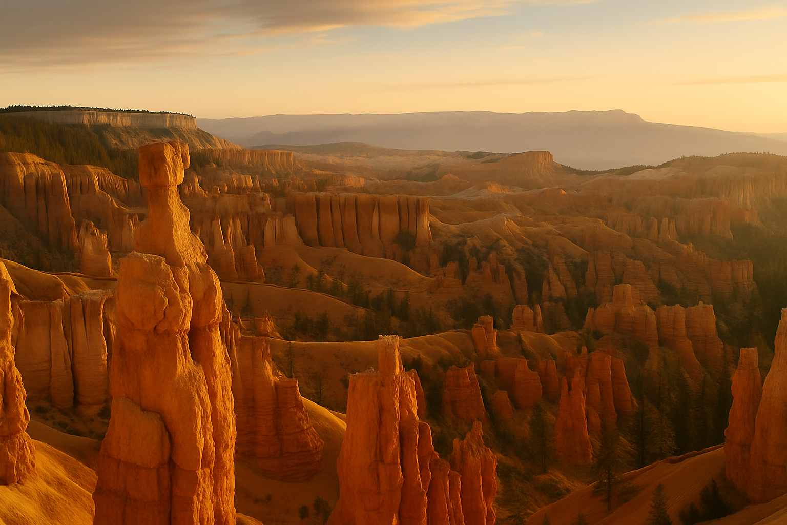
Bryce Canyon isn’t actually a canyon. It’s the eroded edge of the Paunsaugunt Plateau — a series of amphitheaters carved into pink-orange limestone by freeze-thaw erosion, thunderstorms, and a few million years of patience. The result is the highest concentration of hoodoos on Earth: spires, fins, and columns of rock that turn the canyon floor into a landscape you’d expect to find on Mars.
The Navajo Loop and Queen’s Garden trails descend into this landscape. Combined, they make a 3-mile loop that is, mile for mile, one of the best short hikes in the American Southwest.
The Two Trails (Hike Them as a Loop)
Navajo Loop (1.3 miles): Starts at Sunset Point, drops steeply via tight switchbacks to the canyon floor, passes through Wall Street (more on this below), and returns to the rim. Done solo, it’s the shorter, more dramatic option.
Queen’s Garden (1.8 miles): Starts at Sunrise Point, descends through hoodoo formations to a basin centered on a massive white formation that resembles a queen on a chess board (named for Queen Victoria, with some imagination). Gentler switchbacks, more varied terrain.
The combination: Descend via the Navajo Loop from Sunset Point. Cross the canyon floor, connecting to the Queen’s Garden trail. Ascend via Queen’s Garden to Sunrise Point. Take the Rim Trail (0.5 miles, flat) back to Sunset Point. This is the recommended approach — you descend on the steeper trail while your legs are fresh and ascend on the gentler one.
Wall Street
The section of the Navajo Loop called Wall Street is the highlight of the entire hike. Two steep switchbacks lead into a narrow slot canyon flanked by hoodoos over 100 feet tall — the sky visible as a thin strip far above. In the canyon bottom, two enormous Douglas firs grow from the rock, their canopies reaching toward the light. The slot is shaded most of the day, cool even in summer, and completely surreal.
Thor’s Hammer, Bryce Canyon’s most famous hoodoo, is visible from the upper switchbacks — a balanced rock perched on a thin column, improbably not yet fallen.
At the Rim
Sunset Point and Sunrise Point are connected by the Rim Trail, a paved walkway with continuous hoodoo views in both directions. Before or after the hike, walk the rim at sunrise or sunset: the light turns the red-orange limestone pink, then amber, and the long shadows turn each hoodoo into a sundial.
Bryce Canyon sits at 8,000–9,000 feet elevation. This is higher than you think, and afternoon thunderstorms roll in regularly June through August. Plan to be on the rim or back in camp by early afternoon. Lightning in the hoodoos is not an experience to seek out.
Winter Hiking
Here’s the counterintuitive thing about Bryce Canyon: winter is spectacular. Snow collects on the red-orange hoodoos and turns the canyon floor into something from a fever dream. Snowshoes and microspikes are required for the steep switchbacks, but the park keeps trails open year-round. The canyon is quieter, the light is different, and the contrast of white snow against red rock is unlike anything in the American Southwest.
Practical Notes
- No permit required for day hiking. Park entrance fee is $35/vehicle.
- Water: No water sources in the canyon. Bring 1.5–2 liters per person.
- Altitude: Bryce is high — if you’re coming from sea level, take the descent easy and let your body adjust.
- Crowds: Summer mornings are the busiest. Arrive before 8am or after 4pm.
- Cell service: None in the canyon. Download offline maps before going in.
Getting There
Bryce Canyon National Park is 4 hours from Las Vegas, 4.5 hours from Salt Lake City. The park has no gas stations — fill up before entering. The town of Bryce Canyon City (just outside the park) has food and lodging. The Bryce Canyon Lodge inside the park is historic and worth the splurge if it’s available when you book (reserve months ahead).
Coordinates: 37.6254°N, 112.1685°W | Sunset Point, Bryce Canyon National Park, UT