Delicate Arch: Utah's Most Iconic Hike
Delicate Arch: Utah’s Most Iconic Hike
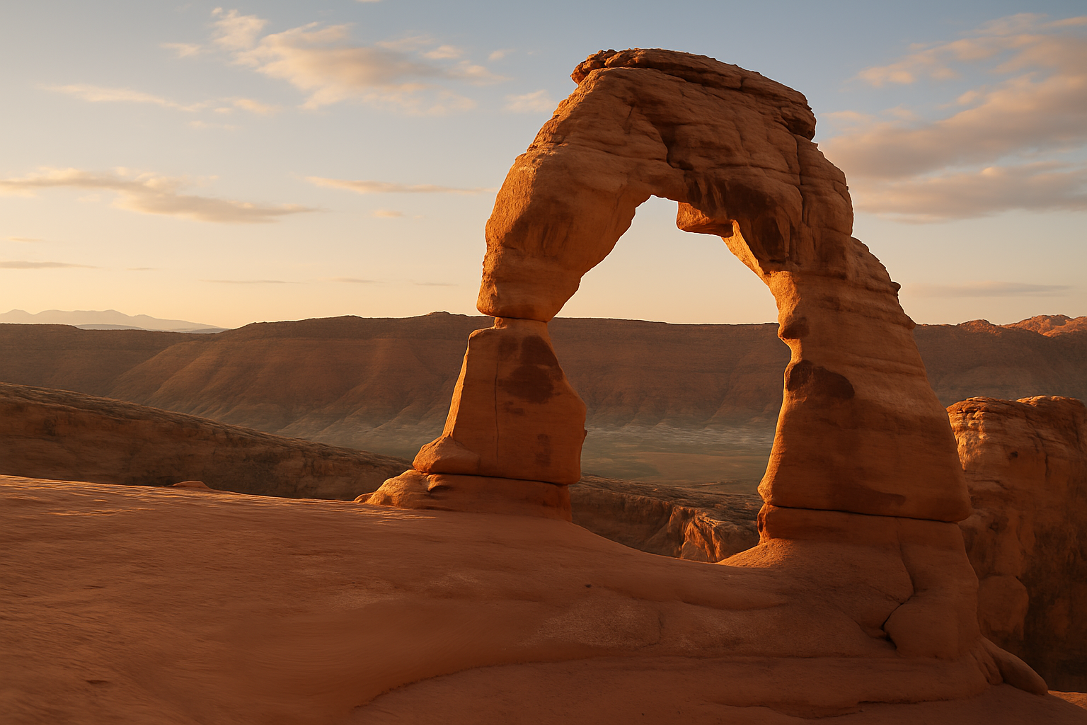
Delicate Arch is on Utah’s license plate. It’s been photographed from every possible angle at every possible light condition. It is, without argument, the most recognizable rock formation in a state that has more remarkable rock formations per square mile than anywhere else on Earth.
The hike to reach it is 3 miles round-trip. It sounds like nothing. It is not nothing — and understanding the difference will determine whether you have a great day or a miserable one.
The Trail
Distance: 3 miles round-trip Elevation gain: 480 feet Difficulty: Moderate — but deceptively demanding in heat Trailhead: Wolfe Ranch, 12 miles from the Arches visitor center
The hike from Wolfe Ranch begins across a footbridge over Salt Wash, passes a small panel of Ute rock art (worth a stop), and then climbs a paved section before transitioning to open slickrock. This is where the trail becomes interesting.
“Slickrock” is a slightly misleading name — the Navajo sandstone underfoot is actually quite grippy when dry. The problem is that it’s exposed. There is no shade for most of the route. The sandstone absorbs heat and radiates it back. In summer, you’re walking across a rock that functions as a very large frying pan.
The trail is marked with cairns across the open rock. Pay attention to them — the route is not always obvious, and wandering off-route in desert heat is not a good situation.
The Final Approach
The last section of trail follows a narrow ledge around the rim of a sandstone bowl. The arch comes into view suddenly — perched on the far side of the bowl, framing the La Sal Mountains in the distance. There are no railings, no fencing, and nothing between you and a significant drop if you step off the ledge. The exposure is real but manageable if you’re paying attention.
The bowl itself is a natural amphitheater. People spread out across the sandstone, eat lunch, photograph the arch from every angle, and generally refuse to leave. It’s one of those places where you keep finding reasons to stay a few more minutes.
The Heat Problem (This Is Important)
Delicate Arch in July at 2pm is a different experience than Delicate Arch in October at 8am — and not in a good way. Summer temperatures in Arches regularly exceed 100°F, and the exposed slickrock amplifies that significantly. Rangers record heat-related distress calls on this trail every summer.
The best times to hike:
- Sunrise: Cool, beautiful light on the arch, minimal crowds. This requires camping nearby or driving from Moab very early.
- Evening: The arch glows orange-red in late afternoon light. Crowds thin after 4pm. Be back to the trailhead before dark.
- Spring/Fall: March–May and September–November. Dramatically more comfortable.
If you’re visiting in summer, go before 8am or after 5pm. Bring at least 2 liters of water per person (no water available on the trail). That’s not a suggestion.
The Crowds
Arches National Park has required a timed-entry reservation for the busiest periods (spring and summer weekends) — check nps.gov/arch or recreation.gov before visiting. Even with reservations, the Delicate Arch trailhead parking lot can be overwhelmed by mid-morning. The park now uses a one-way traffic flow system on busy days.
The arch itself is a social scene — dozens of people at any given time spread across the bowl, taking photos, having the “you take mine, I’ll take yours” conversation with strangers. If you want something closer to solitude, late evening or early morning is the only answer.
The La Sal Mountains in the Background
One of the things that makes Delicate Arch’s setting exceptional is the view beyond the arch — the La Sal Mountains, rising to nearly 13,000 feet, provide a snow-capped backdrop visible for most of the year. The contrast between the red slickrock arch and the white mountains beyond it is genuinely striking. It’s the combination that makes the arch worth the effort, not just the arch itself.
Getting There
Arches is 4 miles north of Moab on US-191. Park entry is $35/vehicle (America the Beautiful pass accepted). The Wolfe Ranch trailhead is 12 miles from the park entrance on the main park road. Moab has abundant camping, lodging, and restaurants — book accommodations well ahead for spring and fall.
Coordinates: 38.7436°N, 109.4993°W | Arches National Park, UT