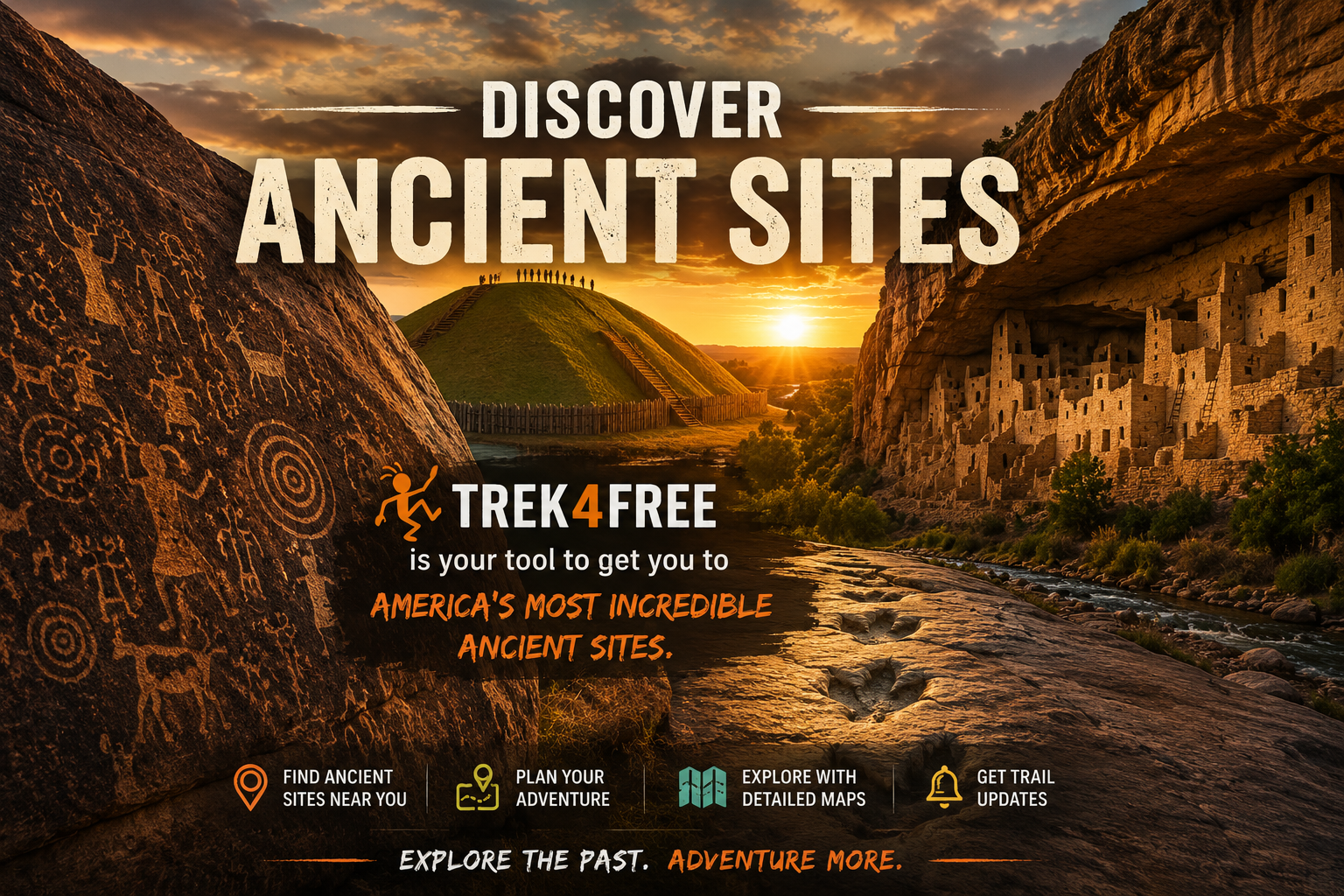
Ancient Sites of America: Petroglyphs, Mounds, Ruins, and the Questions That Won't Go Away
Ancient Sites of America: Petroglyphs, Mounds, Ruins, and the Questions That Won’t Go Away
I grew up in math. And in math, the rule is simple: to disprove a theorem, you only need one valid counterexample. One. The theorem doesn’t get to survive with an asterisk. It doesn’t get grandfathered in as “mostly correct.” One counterexample and it’s done — you go back to the drawing board and build a better model.
Archaeology doesn’t work that way. And I think that’s worth talking about.
The Clovis-first model — humans entered North America by crossing a land bridge from Siberia around 13,000 years ago — was taught as settled fact for decades. Then in 2021, researchers published peer-reviewed findings in Science: human footprints at White Sands, New Mexico, dated to 21,000-23,000 years ago. People walking alongside giant ground sloths, mammoths, and dire wolves. Thousands of years before the ice bridge was theoretically crossable.
In math, that’s game over. Theorem invalid. Build a new one.
In archaeology, it became a footnote.
Then there’s Poverty Point, Louisiana — a massive earthwork complex built around 1700 BCE by a society with no agricultural surplus. The standard model says monumental construction requires agriculture, surplus, and social hierarchy. Poverty Point has monumental construction without any of it. Direct counterexample. The response wasn’t to revise the model — it was to call Poverty Point an anomaly and move on.
In the real world, you don’t get to call things anomalies when the evidence says otherwise. You update your read of the situation or people get hurt.
The good news is the sites don’t care what the textbooks say. They’re still out there — petroglyphs, cliff cities, earthwork pyramids, footprints in ancient lake beds — and you can go stand in front of them yourself. Draw your own conclusions. That’s what this list is for.
Something Ended Everything at Once
Before we get to the sites, one more question that doesn’t have a clean answer.
Around 12,900 years ago, something happened fast. The mammoths were gone. The mastodons. The giant ground sloths. The saber-toothed cats. The American horses and camels. The dire wolves. Nearly every large animal in North America — extinct, together, in what scientists call the Pleistocene megafauna extinction.
The mainstream explanation: humans hunted them out. Overkill hypothesis.
Here’s the problem. A thin layer appears in the geological record at dozens of North American sites at exactly this time — the Younger Dryas Boundary — containing platinum anomalies, nanodiamonds, and microscopic spherules consistent with a massive cosmic impact. It sits precisely where the large animals disappear. Below it: mammoths. Above it: nothing.
The Younger Dryas Impact Hypothesis proposes a comet or its fragments exploded over the North American ice sheet. Rapid climate shift. Continent-wide fires. The Pleistocene ended in a generation.
And almost every human culture on Earth carries a flood story. Sumerian. Hebrew. Hopi. Aztec. Maya. Greek. Hindu. Independent civilizations on opposite sides of the planet with no contact — all describing the same catastrophic event. In my world, that’s not coincidence. That’s multiple witnesses to the same incident.
That’s not mythology. That’s memory.
The Survivors Built Something
Whatever happened 12,900 years ago, people survived it. And what they built afterward — over the following 10,000 years — is scattered across this continent in places most Americans drive past without knowing they exist.
Explore all 31 ancient sites on the Trek4Free map → — select the Ancient Sites filter.
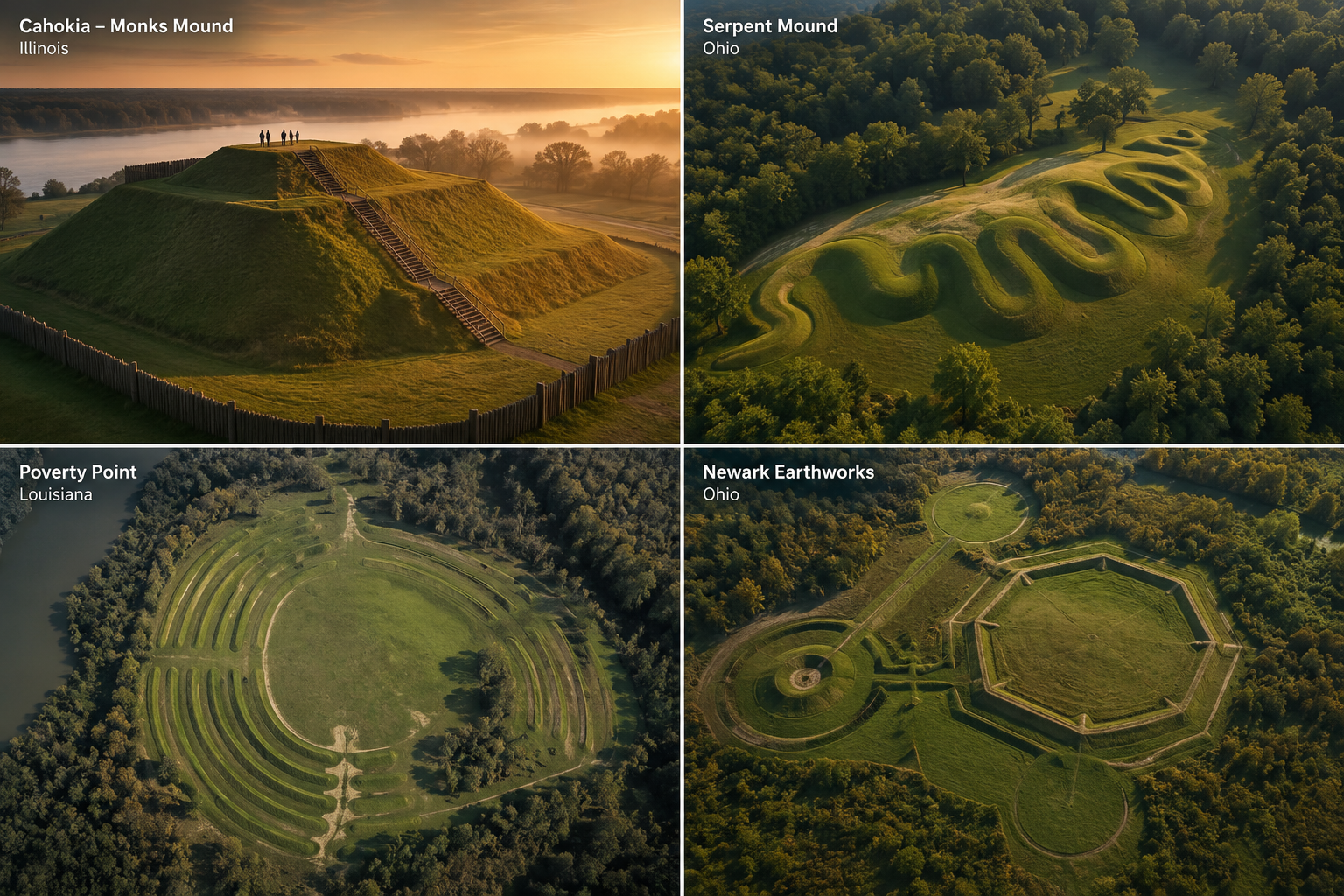
The Mound Builders
The most underappreciated chapter of American history is written in earth.
From roughly 3,000 years ago through 1600 AD, a succession of cultures across eastern and central North America built ceremonial mound complexes of a scale that staggers the imagination. Not because the technology was primitive — because it wasn’t. These were planned cities with sophisticated astronomy, long-distance trade networks spanning the entire continent, and architectural precision that still isn’t fully explained.
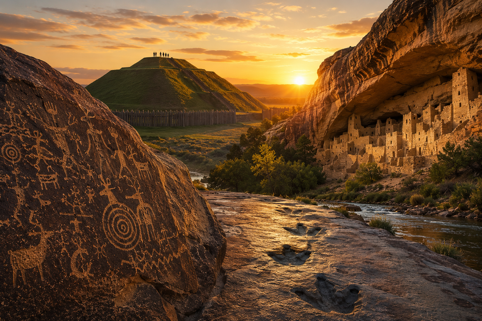
Cahokia (Illinois) was the largest city north of Mexico. At its peak around 1050-1100 AD, it held an estimated 10,000-20,000 people. Monks Mound — the central pyramid — is larger at its base than the Great Pyramid of Giza. It sits eight miles from downtown St. Louis and most people have never heard of it. UNESCO World Heritage Site. Free admission.
Serpent Mound (Ohio) is 1,348 feet of undulating earthwork shaped like a coiled serpent, comprehensible only from the air. It sits inside a 300-million-year-old meteorite impact crater. Whether that’s coincidence depends on how much you believe in coincidence.
Poverty Point (Louisiana) was built by hunter-gatherers around 1700 BCE — which breaks every rule archaeologists use to explain why large-scale construction happens. Agricultural surplus funds cities. Except here it didn’t. A massive earthwork complex, six concentric ridges, 72-foot mounds. Built by people who hadn’t settled down yet. The model doesn’t fit, so the model is wrong.
Newark Earthworks (Ohio) spans four square miles of geometric earthworks aligned to the 18.6-year lunar cycle with a precision that required generations of observation and planning. Part of it is a golf course now. The other part is a UNESCO World Heritage Site you can walk for free.
Find all mound sites on the map →
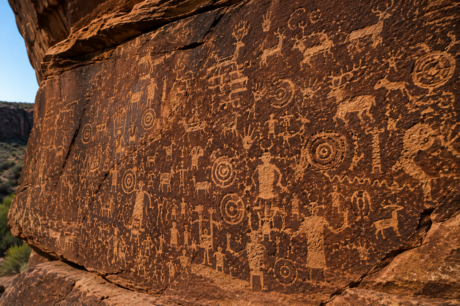
The Message Senders
Someone spent a very long time leaving marks on stone. Not randomly — with intention, repetition, and a visual language we’re still attempting to decode.
Nine Mile Canyon (Utah) is called the World’s Longest Art Gallery. Seventy-eight miles of canyon road lined with Fremont and Ute petroglyphs — over 10,000 panels. The Great Hunt Panel alone is a massive communal scene with hundreds of bighorn sheep and hunters that dwarfs anything in a modern gallery. It’s on BLM land. It’s free. Almost nobody goes.
Newspaper Rock (Utah) is a single sandstone panel covered in 650 petroglyphs spanning 2,000 years — Archaic, Ancestral Pueblo, Navajo, Ute, and Anglo-American images layered on top of each other. Pull off UT-211 on the way to Canyonlands. No fee. The panel is lit at night.
Hueco Tanks (Texas) holds over 3,000 painted pictographs — masks, shamanic figures, and symbols from cultures spanning 10,000 years — tucked into a granite formation 32 miles east of El Paso. The huecos (natural rock basins) that collect rainwater made this one of the only reliable water sources in the Chihuahuan Desert. People have been coming here for water and leaving their mark for ten millennia. The images are extraordinary. Most areas require a guided tour — take it.
Seminole Canyon (Texas) contains Pecos River Style pictographs that are among the oldest and most visually powerful rock art in North America — tall shamanic figures eight feet high, painted in red, black, yellow, and white, dating back at least 4,000 years and possibly 8,000. Hidden 45 miles west of Del Rio in a canyon shelter you can only reach on a guided tour. Worth every step.
Find all petroglyph sites on the map →
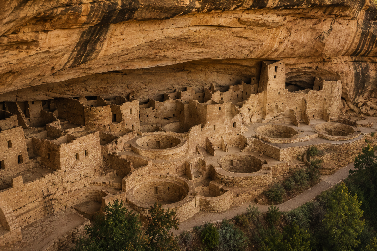
The Cliff Dwellers
Between roughly 900 and 1300 AD, Ancestral Pueblo people built directly into the cliff faces of the Southwest — rooms, villages, and entire cities tucked into alcoves in the canyon walls, accessible only by hand-and-toe holds carved into vertical stone.
Mesa Verde (Colorado) is the largest archaeological preserve in the country — over 5,000 known sites including 600 cliff dwellings. Cliff Palace has 150 rooms and 23 kivas. Standing inside it, looking out across a canyon that hasn’t changed in 700 years, is one of those experiences that resets your sense of scale.
Chaco Canyon (New Mexico) is harder to reach — 20 miles of rough dirt road — and it’s worth every pothole. The canyon was the ceremonial and political center of the Ancestral Pueblo world, with 15 major Great Houses aligned to solar and lunar cycles with astronomical precision. Pueblo Bonito has 650 rooms. The night sky here is extraordinary — and Chaco was an observatory. They were watching the same sky.
Hovenweep (Utah/Colorado border) has towers of a shape and design found nowhere else in the Southwest — square, round, oval, D-shaped — whose purpose is still debated. Astronomical observatory? Defensive tower? Ceremonial structure? Nobody knows. Remote, uncrowded, genuinely mysterious. Primitive camping on site.
Bandelier (New Mexico) is cliff rooms carved directly into soft volcanic tuff, 140-foot wooden ladders into alcove kivas, and smoke-blackened ceilings from fires that burned 500 years ago. 46 miles from Santa Fe. The ladders are worth the climb.
Find all cliff dwelling sites on the map →
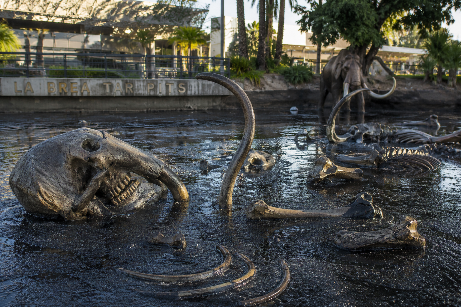
Where the Ancient World Left Its Bones
The fossil record doesn’t lie. It just takes patience to read.
La Brea Tar Pits (Los Angeles) have been trapping and preserving animals for 50,000 years. Over 3.5 million fossils recovered — saber-toothed cats, dire wolves, mastodons, ground sloths. The Page Museum holds one of the finest Pleistocene collections in the world. Active excavations continue during summer. It’s in the middle of a city, and somehow that makes it stranger.
Dinosaur Valley State Park (Texas) — you can stand in a footprint the size of a bathtub, left by a dinosaur that weighed 15 tons, in the bed of the Paluxy River near Glen Rose. Real tracks, real water, real ancient Texas. The same limestone formations that make Pedernales Falls sit here too — this was all seafloor once.
Picketwire Canyonlands (Colorado) holds the largest known dinosaur tracksite in North America — 1,900 individual tracks, 11 miles round trip, remote, no services, almost no crowds. It’s the kind of place that feels like a discovery because most people never make the effort to find it.
White Sands (New Mexico) — the footprints that ended the debate. 21,000-23,000 years old. People walking alongside ground sloths and mammoths, leaving impressions in lake sediment that hardened into record. The discovery site is restricted, but the park itself — 275 square miles of white gypsum dunes — is open and unlike anything else on Earth. Hike it at sunset. Or under a full moon. Either way, you’ll think about time differently afterward.
Find all fossil sites on the map →
If you’re visiting dinosaur track sites, check out the Dino Tracks Challenge → — a Trek4Free badge for explorers who find real tracks in the field. Earn it, download it, put it somewhere your hiking friends will ask about.
The Map
Every site on this list exists, is accessible to the public (most are free or low cost), and sits on the Trek4Free Ancient Sites map →. Select “Ancient Sites” from the filter panel.
These places are not mysteries wrapped in theory. They’re real locations with real evidence of people who lived, built, watched the sky, painted walls, and left marks in stone and earth that have outlasted every empire that came after them.
The questions about what ended the Pleistocene, who the first Americans were, and what the mound builders knew — those are still open. But the sites themselves are there to walk through, touch, and think about.
That’s what trails are for.
Trek4Free maps ancient sites, archaeology, petroglyphs, mounds, and fossil locations across the US — all free, all open. Explore the full map →